
Ilocos Sur (Ilokano: Makin-abagatan nga Ilocos) is a province in the Philippines located in the Ilocos Region in Luzon. Vigan City, located on the mouth of the Mestizo River is the provincial capital. Ilocos Sur is bordered by Ilocos Norte and Abra to the north, Mountain Province to the east, La Union and Benguet to the south and the South China Sea to the west.
Ilocos Sur was founded by the Spanish conquistador, Juan de Salcedo in 1572. It was formed when the north (now Ilocos Norte) split from the south (Ilocos Sur). At that time it included parts of Abra and the upper half of present-day La Unión. The current boundary of the province was permanently defined through Act 2683, which was signed in March 1917.
The province is home to two UNESCO World Heritage Sites, namely, the Heritage City of Vigan and the Baroque Church of Santa Maria.Before the arrival of the Spaniards, the coastal plains in northwestern Luzon, stretching from Bangui (Ilocos Norte) in the north to Namacpacan (Luna, La Union) in the south, were a region called the Ylokos. This region lies in between the China Sea in the west and Northern Cordilleras on the east. The inhabitants built their villages near the small bays on coves called looc in the dialect. These coastal inhabitants were referred to as Ylocos which literally meant from the lowlands. The entire region was then called by the ancient name Samtoy from sao mi ditoy which in Ilocano mean our dialect. The region was later called by the Spaniards as Ylocos or Ilocos and its people Ilocanos.
The Ilocos Region was already a thriving, fairly advanced cluster of towns and settlements familiar to Chinese, Japanese and Malay traders when the Spaniard explorer Don Juan de Salcedo and members of his expedition arrived in Vigan on June 13, 1572. Forthwith, they made Cabigbigaan (Bigan), the heart of the Ylokos settlement their headquarters which Salcedo called Villa Fernandina and which eventually gained fame as the Intramuros de Ilocandia. Salcedo declared the whole Northern Luzon as an encomienda, or a land grant. Subsequently, he became the encomendero of Vigan and Lieutenant Governor of the Ylokos until his death in July 1574.
Augustinian missionaries came to conquer the region through evangelization. They established parishes and built churches that still stand today. Three centuries later, Vigan became the seat of the Archdiocese of Nueva Segovia.
A royal decree of February 2, 1818 separated Ilocos Norte from Ilocos Sur, the latter to include the northern part of La Unión (as far as Namacpacan, now Luna) and all of what is now the province of Abra. The sub-province of Lepanto and Amburayan in Mountain Province were annexed to Ilocos Sur.
The passage of Act 2683 by the Philippine Legislature in March 1917 defined the present geographical boundary of the province.The ancient land of Samtoy.
On the northwestern part of Luzon, the Ilocos range restricts a narrow stretch coastal plain throughout its entire length as the home of one of the tribes of the Malay race, the Ilocanos.
Gleanings from ancient chronicles such as that of Fray Andres Carro say that the word Samtoy was applied to ancient Ylokos or to the most important town of the region, where the most important dialect was spoken.
The ancient land of Ylokos or Samtoy extended from Bangui in the north to Aringay in the south. Situated between the coast of the South China Sea and the rugged mountain ranges of the Cordillera is a long narrow strip of coastal plain. On the western China Sea side, the land is sandy. On the eastern side, near the slopes of the mountains that separates the region from the Mountain Province, the land is rocky, leaving just a narrow strip of plain here and there for cultivation. In places, the mountains come so close to the sea that the public highway has to wind along the steep mountain and sea. The pressure of increasing population and consequent land hunger has made the people of this region thrifty.The coast of Samtoy, already familiar to Chinese and Japanese traders before Magellan's time, was known to the Spanish colonizers in 1572 when Juan de Salcedo traveled along Samtoy or what is now known as the Ilocos Provinces. Sent by the "Adelantado", Miguel Lopez de Legazpi, to explore the whole island of Luzon, Salcedo founded Ciudad Fernandina in 1574 in the heart of Yloko settlement in Bigan, in what is now Ilocos Sur. It became the center of Spanish rule and influence, and the evangelization and pacification movements.
The Spaniards, after Salcedo's exploration, created Samtoy, the whole northwestern region of Luzon into an encomienda with Villa Fernandina at Tamag (Bigan) as the capital.
Salcedo was made lieutenant governor of Ylokos and the encomendero of Bigan where he died on March 11, 1576. It was due to his efforts that the settlements in Tagurin, Santa Lucia, Nalbacan, Bantay, Candon and Sinayt were pacified and made to pay tribute to the King of Spain.To implement Spain's policy, missionaries came to convert the natives to Christianity. A Spanish chronicler[who?] wrote: "The Ilocos are all Christians and are the humblest and most tractable.
The evangelization of Ilocos Sur was allotted to the Augustinians who established parishes in Santa in 1576, Tagurín in 1586, Sta. Lucía in 1586, Nalbacán in 1587, Candón 1591, and Bantay in 1590. In 1641 they built a church in Bigan, which 117 years later, was to become the cathedral of the Episcopal See of Nueva Segovia.Ylokos comprised the present provinces of Ilocos Norte, Ilocos Sur, Abra, and a part of Mountain Province.
A royal decree dated February 2, 1818, separated the northern section of Ylokos which became the province of Ilocos Norte. The southern portion, called Ilocos Sur, included the northern part of La Union and all of what is now the province of Abra. In 1854, the province of La Unión was created out of the towns that had belonged to Ilocos Sur and Pangasinan. Ilocos Sur previously extended as far south as Namacpacan (in Luna), and the territory south of this belonged to Pangasinan. It was the union of portions of Ilocos Sur from the Amburayan were taken from the Mountain Province and incorporated with Ilocos Sur.
Abra, which was part of Ilocos Sur, was created in 1864 with Lepanto as a sub-province to Ilocos Sur, and remained as such until March, 1971 when the passage of Act made it again a separate province.Vigan is almost four centuries old, and was once known as Kabigbigaan from biga (Alocasia Indica), a coarse erect and araceous plant with large and ornate leaves with grows on the banks of the rivers. Its name Bigan was later changed to Vigan. To the Spaniards it was Villa Fernandina in honor of King Ferdinand, the Spanish ruler then.
Founded in 1574 by Spanish conquistador Juan de Salcedo as capital of ancient Ylocos, Vigan vied in importance and gentility with the city of Intramuros. Even before Salcedo came to Bigan, the town was already a center of Malayan civilization with a population of 8,000, a population greater than that of Manila then. It was already enjoying some prosperity, trading with the Chinese and Japanese who brought fine jars, silk and crockery through the nearby port of Pandan, Caoayan.
In the 19th century, Vigan also traded with Europe. Ships loaded indigo in its port for the textile mills in the Continent. The invention of chemical dyes in Germany ruined this industry. By then, the affluent citizens of Vigan had stocked their homes with statuettes of brass and iron, dinner wares, other artifacts of European civilization, fine ivory and inlaid furniture and China wares.In the development of Ilocos Sur, the colonizers utilized free labor. Resentment to free labor brought about sporadic revolts, and those who refused to be slaves and tenants left the region and went to Abra and Cagayan Valley. From 1898 to the first decade of the 20th century, covered ox carts moved to the rich plains of Pangasinan, Nueva Ecija and Tarlac.
In these travels, the children were amused by the tales of Lam-ang, Angalo and Aran, Juan Sadot and other legendary Ilocano characters. Folk songs like Pamulinawen, Manang Biday, Dungdungwen Kanto Unay, Unay, and the Iloko dal-lot, to the accompaniment of the kutibeng were popularized.
The second phase of Ilocano migration was from 1908 to 1946 when surplus labor hands migrated to the plantations of Hawaii and the American West Coast. At the height of this migration, the average density of population in Ilocos Sur was 492 inhabitants per square mile, the most dense in the Philippines then, excluding Manila. The last batch of labor migration of Hawaii was in 1946 when 7,365 men were recruited by the Department of Labor. Vigan was the recruiting center. At present, more than seventy percent of the 63,500 Filipinos in Hawaii are Ilocanos.The history of Ilocos Sur, from the beginning of the Spanish rule to the first decade of the nineteenth century was characterized by revolts in protest against tributes and forced labor, as well as the monopolies of some industries.
The best known of these revolts was the Ilocos revolt (1762-1763), better known as Silang's Revolt. This was principally a revolt of the masses aimed at the Babaknangs and the alcalde-mayor of Vigan. After Diego Silang's assassination on May 28, 1763, his wife, Josefa Gabriela, continued the fight until she was captured and hanged publicly on September 20, 1763.
On September 16, 1817, another revolt resulted in protest against the government's monopoly in the manufacture of basi the native wine. The rebels under the command of Ambaristo were defeated by a contingent of regular troops and recruits.
On March 25, 1898, Isabelo Abaya started a revolt in Candon and raised a red flag in the town plaza. The historic Ikkis ti Candon was the start of the several revolutions in the Ilocos Region.Ilocos Sur, like other provinces in the Philippines, was quick to rally behind Gen. Emilio Aguinaldo in the Philippine Revolution in 1896. Upon the capture of Vigan, the revolutionists made the Bishop's Palace, their headquarters. On March 21, 1898, Don Mariano Acosta of Candon established the provincial revolutionary government in that town.
When General Aguinaldo returned from his exile in Hong Kong to begin the Philippine–American War, he sent General Manuel Tinio to carry on the guerilla warfare against the Americans. Vigan served as Tinio's headquarters until its occupation by the U.S. 45th Infantry under Lt. Col. Parker on Dec. 4, 1899.
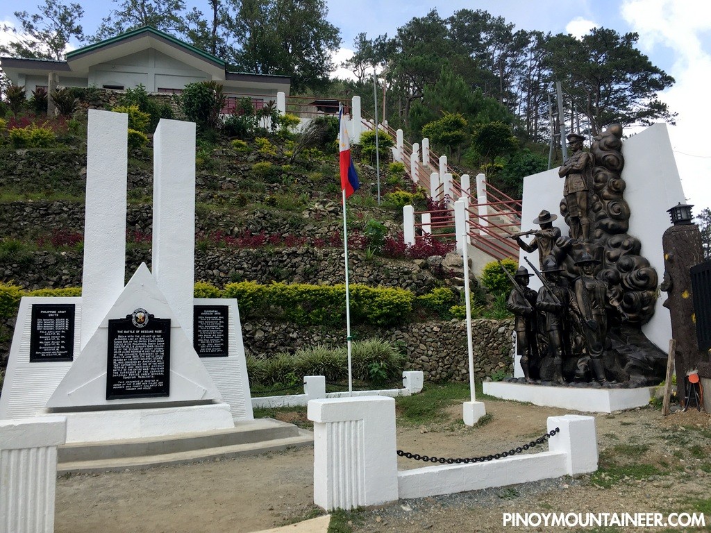
On the Tirad Pass in Concepcion, east of Candon, General Gregorio del Pilar, covering the retreat of General Aguinaldo to the Cordilleras and ultimate to Palanan, died a heroic death on December 2, 1899 in a battle against the American Forces under Major C. March.
With the smoldering embers of the Filipino-American War already dying out, and with the gradual return of peace and order, a civil government under the Americans was established in Ilocos Sur on September 1, 1901 with Don Mena Crisologo, a delegate to the Malolos Congress, as the first provincial governor.About forty years later, another bloody skirmish took place in Vigan, On December 10, 1941, a contingent of Japanese Imperial forces landed in Mindoro, Vigan, Santa, and Pandan, Caoayan.
Four years later, the Battle of Bessang Pass in Cervantes, fought between General Yamashita's forces and the U.S. 21st Infantry was the climax in the fight for liberation. On April 18, 1945, Ilocos Sur was declared liberated from the Japanese with the joint efforts of Filipino & American soldiers including Ilocano guerrillas.The first half of the 19th century was an economic boom for Ilocos Sur and other Ilocano provinces. It was during this period when the cotton, tobacco and indigo industries were encouraged by the government. With the operations of the Real Compania de Filipinas, the textile industry was developed on a large scale, and the abolition of the tobacco monopoly accelerated economic progress. But the invention of chemical dyes put the indigo industry out of the business scene.
Today, the premier money crop is Virginia leaf tobacco. The windfall was brought about by the Tobacco Subsidy Law, authored by Congressman Floro Crisologo.The 1970s were a dark period for the province as armed men known as the saka-saka (Ilocano, literally "bare-footed") terrorized the province; and this reign of terror resulted in the famous burning of the barangays of Ora East and Ora Centro in the municipality of Bantay. This era ended with the rise of Luis "Chavit" Singson to the governor's seat.
Ilocos Sur occupies the central section of the Ilocos Region in northern Luzon. It is bordered by Ilocos Norte to the north, Abra to the northeast, Mountain Province to the east, Benguet to the southeast, La Union to the south, and the South China Sea to the west. Its area of 2,596.00 square kilometres (1,002.32 sq mi)[5] occupies about 20.11% of the total land area of Region 1.
The topography of Ilocos Sur is undulating to rolling with elevations ranging from 10 to 1,700 metres (33 to 5,577 ft) above sea level.The population of Ilocos Sur in the 2015 census was 689,668 people, with a density of 270 inhabitants per square kilometre or 700 inhabitants per square mile.
The 1960 census lists 338,058 people; 64,446 dwelling units of which 2,974 are lighted with electricity; 3227 provided with radio; 7379 served with pipe water; 25,137 served with artesian and pumped water; and 310 using electricity, kerosene and gas for cooking.Ilocos Sur is inhabited mostly by Ilocanos belonging to the third largest ethnic group of Malay origin. A Spanish chronicler[who?] wrote that “the people are very simple, domestic and peaceful, large of body and very strong. "They are highly civilized. They are a most clean race, especially the women in their homes which they keep very neat and clean."
Miguel de Loarca records around 1582 that the Ilocanos are intelligent as the Zambaleños for they are farmers. The main occupation of the people is agriculture.
Father Juan de Medina noted in 1630 that the natives are "the humblest and most tractable known and lived in nest and large settlements".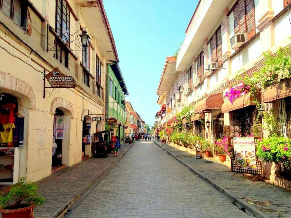
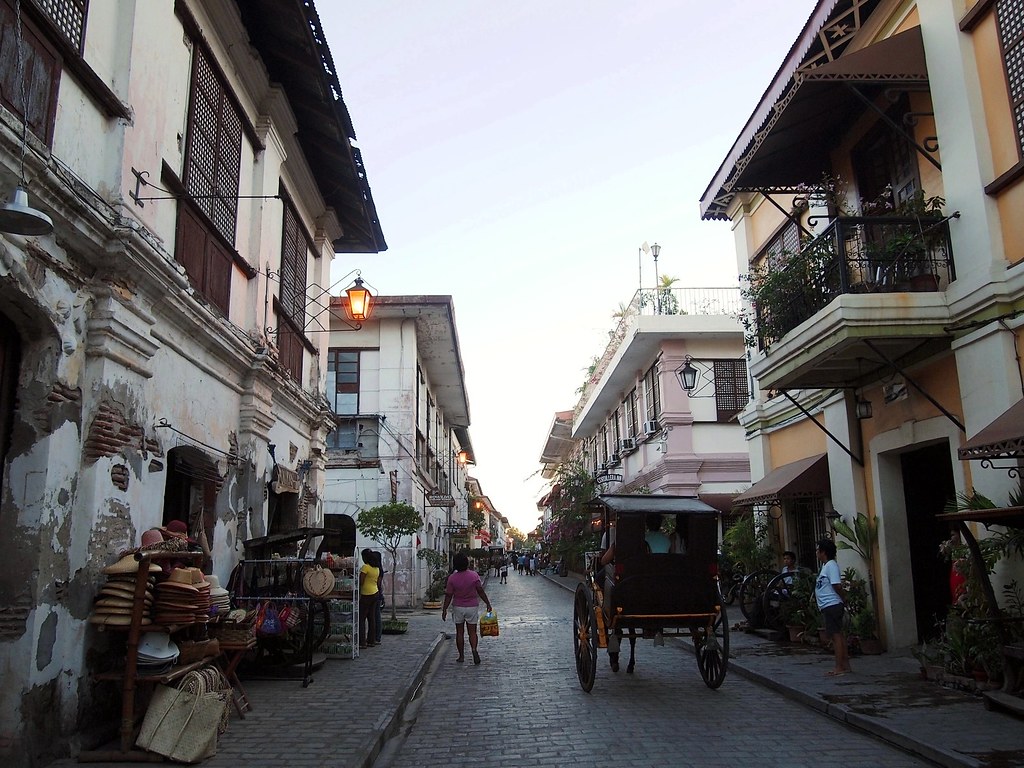
The major attraction of Vigan is its mestizo district which is filled with Spanish-style houses that evoke a bygone era when its people lived prosperously because of the Manila-Acapulco maritime trade. For visitors who want to experience being transported back to this period in Philippine Spanish colonial time, a walk or a calesa ride through Vigan’s Calle Crisologo or Mena Crisologo Street is a must. The tour will take visitors more than a couple of hours and will cost around half a thousand pesos. You will be guided through four blocks of cobblestone streets lined with heritage houses of the families of the Filipino-Chinese traders who rose to prominence during that time of vigorous trading in abel cloth, indigo, gold, tobacco and other goods that were transported to Vigan from all over the North.
The houses are simple but lovely subjects ready for picture-perfect shots with their roofs of red tiles, thick walls, huge doors and stair cases leading to rooms of high ceilings and sliding capiz shell windows. Having survived the many natural and man-made calamities throughout the centuries, the families who own these treasures have endeavored to maintain them. Visitors can admire more closely the architecture and intricate craftsmanship employed in the grill and wood works when they step inside some of the houses that have been turned into stores and museums. They can even experience staying in a heritage house during their visit as some have been converted into inns.
Though a trip to Calle Crisologo is enjoyable during the day especially because of the opportunity to shop for Vigan’s best products (antiques, abel woven products, bags, basi wine, burnay and dimili products, chicharon, jewelry, sweets, Vigan vinegar and woodcrafts) in the inobtrusive shops located in the ground floor of some of the grand houses, a walk through it is magical at night. Since it is closed to vehicular traffic at any time of the day, the stillness and shadows that come with the night adds more to the 18th century ambience of the lamp-lit street that local and foreign visitors love. Couples can take advantage of this romantic atmosphere by having dinner in one of the old houses that has been converted to a restaurant, like Café Leona, before or after their walk.
For those who want to know something about the person the street is named after, Mena Pecson Crisologo is among the most-respected sons of the Ilokos region. He wrote Mining wenno Ayat ti Kararwa, which many compare to Jose Rizal’s Noli Me Tangere; an Ilocano translation of Don Quixote entitled Don Calixtofaro de la Kota Caballero de la Luna; and a zarzuela entitled Codigo Municipal.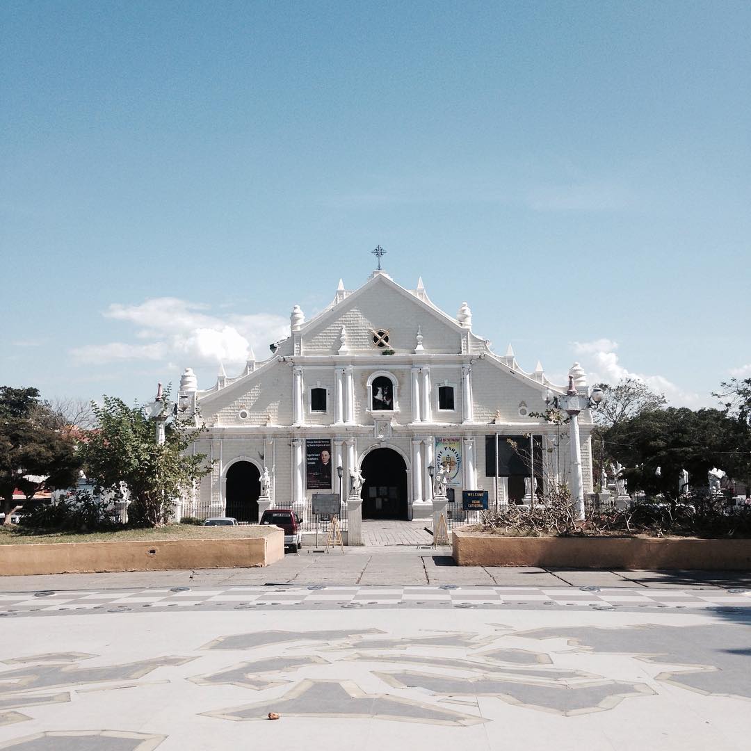
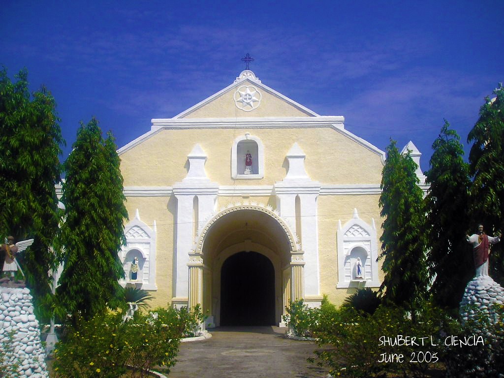
The St. Paul’s Cathedral is also known as the metropolitan Cathedral. It is considered a major religious landmark not only of northern Luzon but the country as well. Visitors must include a visit to the cathedral when in Vigan as it has been a center of Roman Catholic devotion for centuries. The church as it stands now was completed in 1800. The original structure was built in 1574 upon the command of the Spanish founder of Vigan, Juan de Salcedo. It was a mere chapel then, made of wood and thatch. In 1641, the chapel was replaced by a church.
When the seat of the Nueva Segovia Diocese was transferred to Villa Fernandina de Vigan from Cagayan’s Lal-lo in 1758, the church was elevated to the status of a cathedral and became the center of Catholic faith in the north. Another structure was ordered by then Governor Jose de Basco to be built to replace the existing church in 1786. With the Augustinians, the cornerstone of the new church was laid in the beginning of 1790.
Overall, the cathedral follows a Baroque architectural design that has been modified by Ilocanos to strengthen the structure against earthquakes. This is now known as earthquake Baroque. Testament to the style’s effectivity is the fact that the structure’s original interior walls have remained complete.
Other influences can be observed from the architecture of St. Paul Cathedral, that of neo-Gothic, pseudo-Romanesque and Chinese craftsmanship. Facing the cathedral, visitors are greeted by the statue of St. Paul above the main opening. There are also carvings of Fu dogs or lion dogs by the outermost doors. In the alcove are scenes of Saint Paul’s conversion. Though some people may find that the façade is not as impressive as other churches, the cathedral’s interior is something to be admired. The presence of a silver-paneled main altar, three naves,
12 minor altars and brass communion handrails forged in China gives the inside of the church a feeling of grandeur. The area for the choir is located at the loft, making use of the big church’s acoustics.
Surrounding St. Paul Cathedral are the other historic buildings of the city. There are the Episcopal Palace or the bishop’s residence, the diocesan seminary and the Vigan Municipal Hall. It is also beside two plazas, one named after Vigan’s founder, Plaza Salcedo, and another named after a revolutionary hero, Plaza Burgos. It shows how central the cathedral’s role is not only in the religious life of the people, but the social, economic, educational and political aspects as well.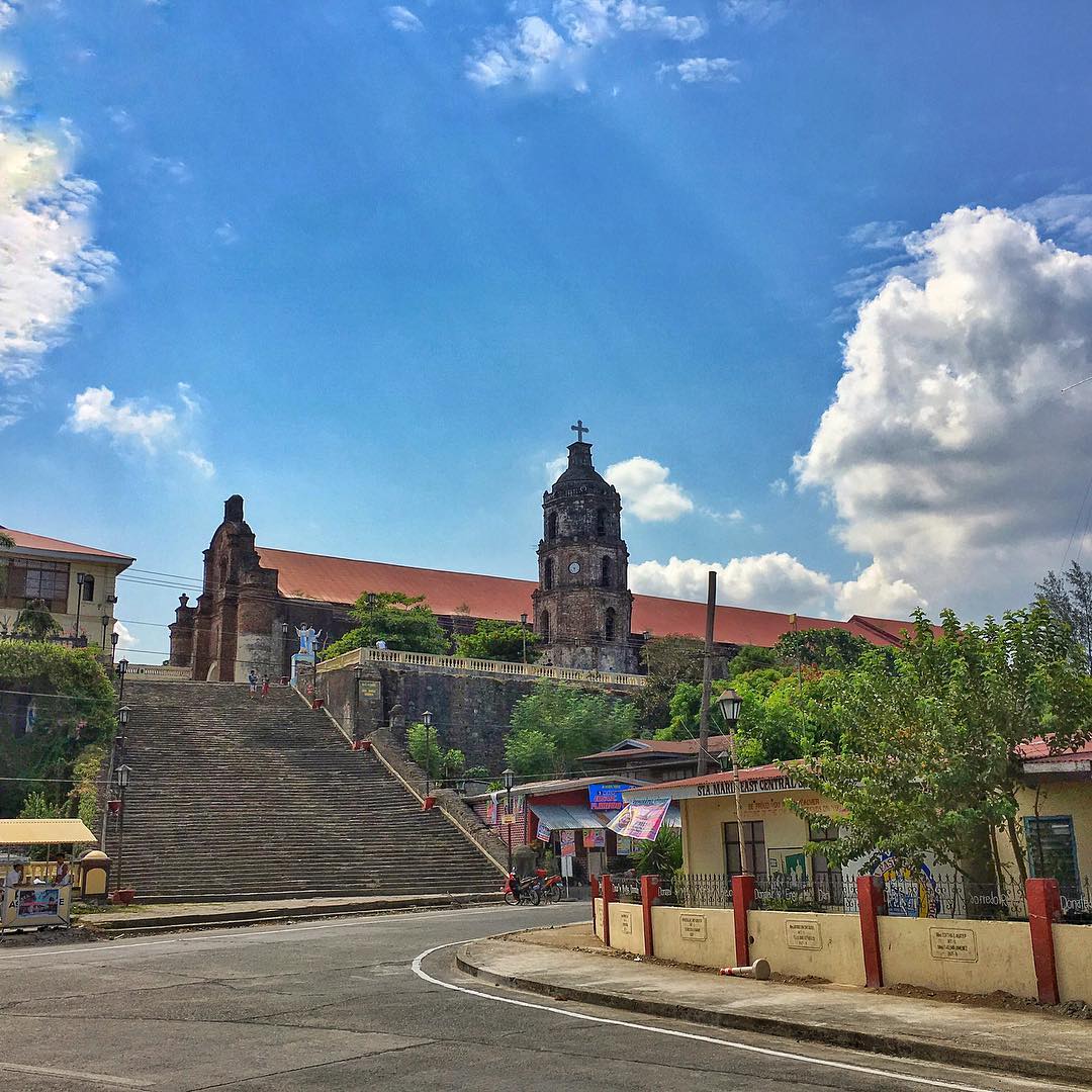
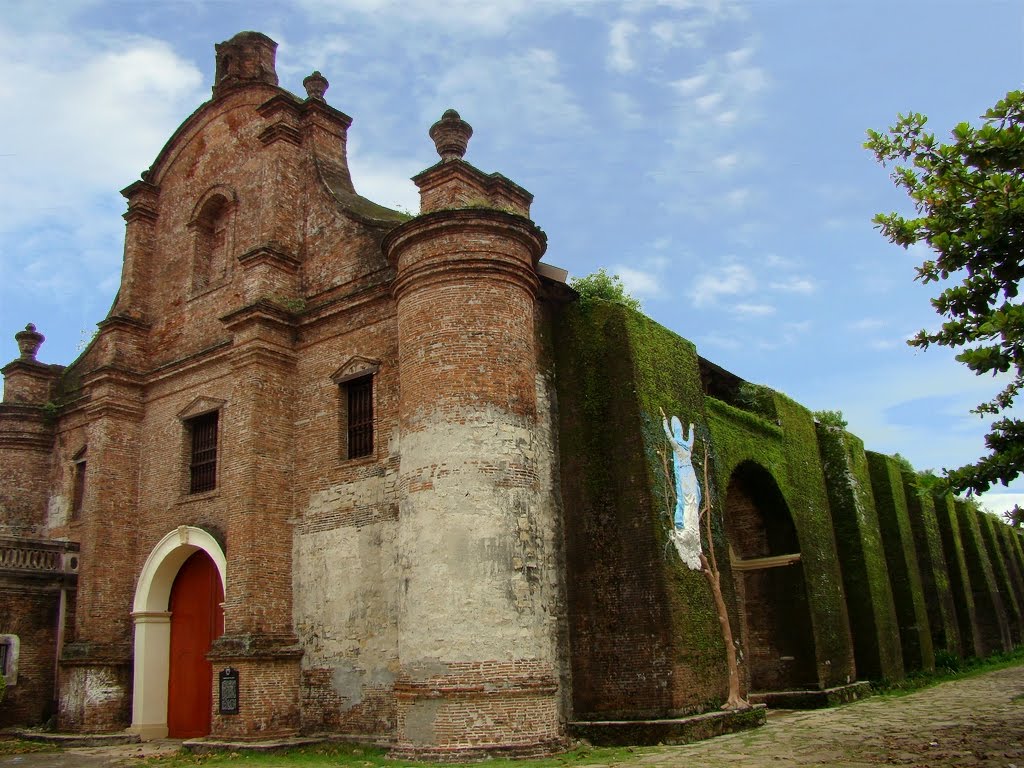
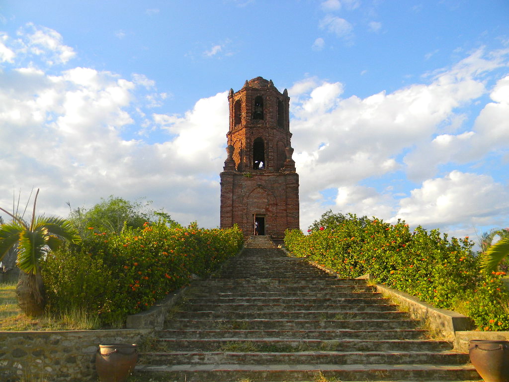
The Church of Our Lady of the Assumption (Nuestra Señora de la Asuncion), commonly known as the Santa Maria Church is the parish church of Santa Maria in Ilocos Sur province, Philippines. The church was designated as a UNESCO World Heritage Site on December 11, 1993 as part of the Baroque Churches of the Philippines, a collection of four Baroque Spanish-era churches.
The Santa Maria Church is an attraction to both tourists and Catholics in Ilocos Sur. It is not only a reminiscent of the four centuries of Spanish domination of that area but also a unique structure with a diversified architectural design of bricks and mortar. It was built on top of a hill not only as a lookout and a citadel but as a religious center during the early administration of the region by both the friars and soldiers of Spain.
A UNESCO World Heritage and one of the four beautiful baroque churches in the Philippines lies behind the town of Sta. Maria in Ilocos Sur.
Situated in the town center and sitting on top of a hill is Santa Maria Church, also known as The Church of Our Lady of Assumption. Baroque Churches in the Philippines was first built during the Spanish Colonial Period. Spanish missionaries, along with Filipinos and Chinese migrants, were some of the people who influenced the design of the baroque churches highlighting Spanish structures.
One of the four baroque churches in the country is the Santa Maria Church that was built by the Augustinian friars as a chapel for the town of Narvacan back in 1769. 40 years later, the bell tower beside the church was built in 1810, as a home for missionaries going to Abra.
While most churches around the country are situated just across the town square or the municipality, Santa Maria Church is situated on top of a hill, overlooking the town and can be accessed through an almost 80 concrete steps going up.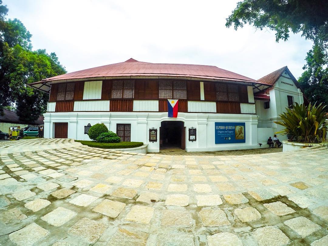
This museum is the ancestral house and birthplace of priest patriot Fr. Jose Burgos. Known as Padre Burgos House, it is one of the notable historic structures of Vigan, the capital of the province of Ilocos Sur. It is a two-story structure located near the Provincial Capitol and close to St. Paul’s Metropolitan Cathedral. It was renovated by the Filipinas Foundation, Inc. and inaugurated on May 3, 1975. In January 1989, a Contract of Lease was executed by the Ilocos Sur Historical and Cultural Foundation, Inc. leasing the memorabilia for 50 years, and turning over the administration to the National Museum.
Vigan is strategically located at the delta of Abra River and was the center of political, religious, economic, social and cultural activities in Northern Luzon for more than three centuries. This city became the hotbed of social unrest against colonial abuses. Among those who led the cause for patriotism were the Bigueños Fr. Jose Burgos, the poetess Leona Florentino, her son Isabelo de los Reyes (father of Philippine Labor Unionism) and Elpidio Quirino, the second President of the Republic.
The historic city of Vigan was inscribed as a UNESCO World Heritage Site on December 2, 1999.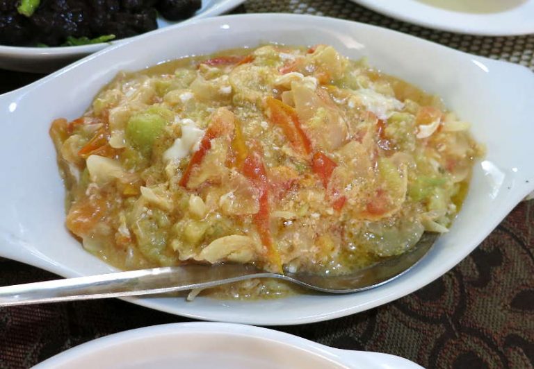
This simple Ilocano dish will please any vegetarian. In a country, where pork is a daily staple, it is hard to find any dish that is not served with meat or fish. However, you will find eggs battered in Poqui-Poqui.
Poqui-poqui is made of grilled eggplants sauteed with onions, garlic and tomatoes. Eggs are added and stirred with the other ingredients. All the ingredients are cooked together making this Ilocos delicacy slightly soupy.
Don’t be deceived by this simple dish. We found Poqui-poqui to be a very refreshing dish, easy to eat with lighter ingredients than the other Ilocanos dishes. It can be eaten as an appetizer, a main dish or a side dish.
The unusual name Poqui-poqui, is said to have originated from Hawaii where Filipinos migrated in the 1980’s. There, the word “poki” means “mash” or “slice” which aptly describes the texture of this Ilocano dish. You may find this dish written as “poki-poki” or “poqui-poqui”.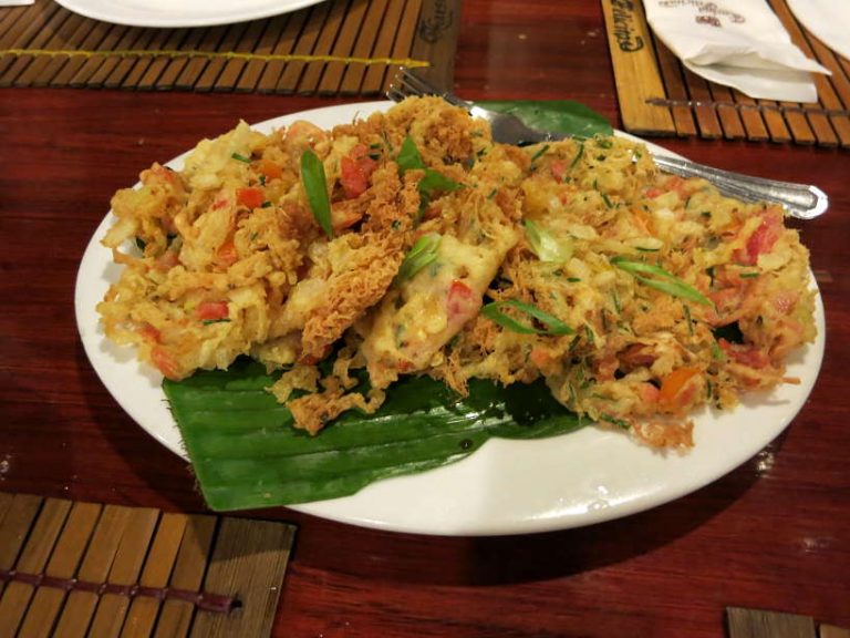
These delicious treats are crispy shrimp fritters cooked in their shell in a glutinous rice batter and shaped into a round form. These fritters are garnished with fresh shallots and a mix of garlic and chili peppers.
The unique flavors come to life when dipped in an Ilocos style vinegar called sukang iloko.
We enjoyed these flavorful fritters as snacks. These Ilocanos delicacies are an easy bite while waiting for dinner.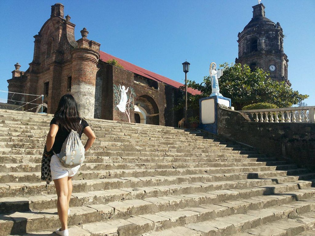 |
 |
 |
 |
 |
 |
 |
 |